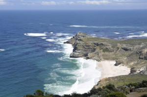
In 1487, Portuguese explorer Bartholomew Diaz and his crew sailed south from Lisbon along the western coast of Africa, hoping to find a sea route to India. Diaz managed to sail east after reaching the southern coast of Africa, but his frightened sailors refused to continue. On the return trip, Diaz encountered a rocky headland jutting into the ocean that he named “The Cape of Storms” because of violent weather in the area. His patron, King John II, renamed the point the “Cape of Good Hope” because it proved sailing to India was feasible.
The king’s optimism was justified. In 1498, Vasco de Gama “rounded the Cape of Good Hope” and continued until he reached India. The notion of “rounding the Cape” has long suggested that the Cape of Good Hope is at the southern tip of Africa. It is not. To the east, little-known Cape Agulhas extends further south. Cape Agulhas is also where the warm currents of the Indian Ocean bump up against the cooler currents of the South Atlantic, creating turbulent weather. Cape Point tourists, having never heard of Cape Agulhas, buy tee-shirts incorrectly saying they have seen “where two oceans meet.”
To reach the hilltop offering the best view of the Cape of Good Hope, visitors to Cape Point ride “The Flying Dutchman,” a funicular named for a legendary Dutch ship reportedly lost off the Cape of Good Hope during a storm. According to a 17th century tale, the ship and its ghostly crew are destined to sail the oceans forever, foretelling doom to anyone catching sight of the glowing ship. After seeing the Cape of Good Hope, the adventuresome can look for 250 species of birds and several troops of baboons. They can also try to avoid spotting the Flying Dutchman.
